|
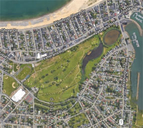
The Winthrop Playstead is a term that was used in the
late 1800s and early 1900s to describe the land that now includes Lewis Lake
Park, the Winthrop Golf Course, Miller Field, Little League Field, and the
new Winthrop High School and Middle School and its surrounding baseball fields. Though
seldom used now, except in proper names, the word playstead, comparable to farmstead or homestead,
describes a field or land that is meant for playing sports.
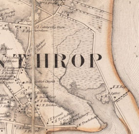
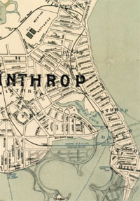
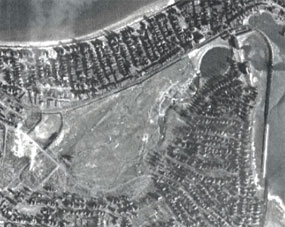
Originally called Fisher's Creek, and later renamed Crystal Cove, the
Playstead was originally a saltwater inlet and marsh open to the ocean (see
Bake & Tilden 1866 map). The land was owned from 1869 to 1883 by the City of Boston,
then was acquired by Winthrop.
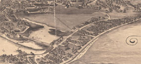
By 1884 a pile bridge had been constructed
extending Washington Ave. to Shirley St. (see 1894 aerial drawing and 1901 Coast
Guard map). Filling on either side of Washington Ave. closed in what would
become Lewis Lake (named after Orlando Lewis) (See Lewis Lake Park). Other than for
a few trails, there was of yet, no development in the area.
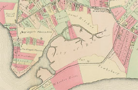
In the
1903 map by the real estate firm Floyd & Tucker, the whole Playstead area, except
for Lewis Lake, is crisscrossed with proposed streets. One proposal by the
Winthrop Land Trust Co., a real estate firm run by Boston merchants, George A.
Goddard and Alexander S. Porter, was to create a new development between Revere
St. and the Narrow Gauge Railroad line behind the Ocean Spray land along the
beach. Crescent St. was laid out to run on the other side of the tracks from
Shirley Ave., and a series would connect it with Revere St. Only short portions
of proposed streets were built, and the land was eventually used for the a
Winthrop High School.
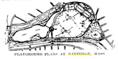
Another proposal for the Playstead land appeared in the 1913 Municipal Journal and
Engineer (see diagram):
"Plans for an elaborate playground in Winthrop which will not be surpassed by any
in or around Boston have been completed by the Winthrop Improvement and
Historical Association. The plans call for the beautification of what is now
known in Winthrop as the Playstead. It is in that section of the town extending
from the Center to the beach and taken by the town three years ago for
playground purposes. The land with the body of water known as Lewis Lake
contained in the property comprises 5 per cent of the total area of the town. At
present it is used by the children. Three baseball diamonds have been
constructed on it. The lake is also used for skating at times. The plans call
for every sort of recreation devices. Certain spaces are set aside for baseball,
others for tennis courts, squash ball, football, a running track, a concert
grove, and a myriad of other things especial attention being paid to amusements
for small children such as sand pits swings trapezes and horizontal bars.".
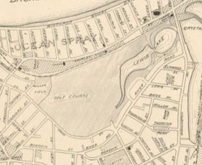
In 1917 part of Playstead was leased to create the Winthrop Golf Club.
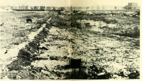
In 1937 the Playstead was improved under a WPA project:
Work Relief Success in Winthrop
"Winthrop, at the southernmost tip of the North Shore, directly across the harbor from Boston, has considerable natural beauty. Its naturally attractive setting has been enhanced by work relief projects in recent years. The town where Gov. Winthrop and his son Dean lived three centuries ago had one unattractive feature. The town was built around an ugly marsh and a pond called Lewis Lake.
Because of WPA and the Winthrop Golf Club the formerly ugly marsh is now a recreational beauty spot. The golf club reclaimed a spot in the centre of the marsh and created a nine-hole course.
At the north end of the former swamp, WPA raised the level a half dozen feet and built William A. Miller Athletic Field in honor of one of Winthrop's sens killed in action in France during the world war. Clay from Winthrop Highlands and sand from Point Shirley formed a firm basis for Miller Field in the days of CWA and ERA when Howard Shattuck, superintendent of the Winthrop water department, doubled in brass, so to speak, and directed work relief activities without pay in addition to his regular job as water department superintendent.
Work relief labor has built Simon J. Donovan Beach, dedicated to another Winthrop boy cut down by a German bullet a short time before the Armistice. The beach accommodates residents of the Court Park section of the town (en the Boston harbor side).
Another outstanding project in Winthrop is the sea wall being built from the Winthrop Yacht Club to the narrow, sea-girt road which leads to Point Shirley. Here pounding waves had undermined the old-fashioned seawall. WPA has built a sloping sea wall which can better break the chop of the waves in front of Shirley street, protecting the street from erosion and the site of the first house built by Governor Winthrop. The Dean Winthrop House, built in 1639 and to which the governor's son. Dean Winthrop, took his bride, is still standing.
These are only a few of the many WPA projects in Wmthrop which have given material benefits to the town in addition to providing unemployed men and women with work. Winthrop also has had its share of street, sewer and water main projects. Space does not permit mention of the many projects which have been completed and are in progress at Fort Banks. We shall discuss Fort Banks projects in a later article.
|
 |